A Guide to the Cranbrook Hill Greenway
First Edition
Prepared by
Natalie Ciolfitto
Fall 1997
Cranbrook Hill Greenway Society
Prince George, B.C.
Acknowledgments
A special thank you is given to the BC Provincial Government for granting the Cranbrook Hill Greenway Society with ETeam funding. This funding allowed the society to hire an intern to research and prepare the first edition of the Cranbrook Hill Greenway Guidebook.
Thank you to Canfor for allowing access to a computer during the three months needed to complete the guidebook. Special appreciation given to Canfor employee, Kevin Gillespie, for organizing the use of a computer.
Members of the community including Mrs. Teschke, Roman Hildebrant, and Gary and Cathlene Paulson kindly donated their time for a series of interviews to gain more insight on the natural and cultural history of Cranbrook Hill. Thankyou for the interesting information you provided for the guidebook.
Special appreciation is given to Robin Draper, Dick Voneugen, Jack Bowling
and Jim Weed for their aid in developing the Guidebook.
Section 1: Introduction
What are Greenways?
The concept of “greenways” is fairly new having evolved from work in the USA where the first greenways were established in the mid-seventies. A greenway is a linear open space established along either a natural corridor, such as a river front, stream valley, or ridgeline, or over land along a railroad right-of-way converted to recreational use, a canal, scenic road, or other route. It is any natural or landscaped course for pedestrians, equestrian or bicycle passage; or open space connector linking parks, natural reserves, wildlife habitat corridor, cultural features, or historic sites with each other and with populated areas or a certain strip of linear park designated as parkway or greenbelt (paraphrased from Little, C. Greenways for America 1990).
The Cranbrook Hill Greenway is a mixture between two greenway types hoping to achieve harmony between recreationalists and wildlife. The two greenway types that the Cranbrook Hill Greenway resembles are:
Recreational greenways, featuring paths and trails of various kinds, often relatively long distance, based on natural corridors as well as canals, abandoned railbeds, and public right-of-ways.
Ecologically significant natural corridors, usually along rivers and streams and less often ridgelines, to provide for wildlife migration and species interchange, natural study, and hiking.
Purpose of the Cranbrook Hill Greenway
The purpose of the Cranbrook Hill Greenway is to secure recreational and naturalist opportunities for present and future generations of Prince George in the face of continuing urban development. The greenway is more than just a trail, but a linear area of approximately 324 hectares that will provide a corridor for wildlife habitat and recreation activities. The greenway fulfills it’s purpose by connecting currently used sites on Cranbrook Hill, including Otway Ski Center, Forests for the World, UNBC, and Parkridge Creek.
The City of Prince George is growing at an unprecedented rate and as such it is vital that areas like this greenway be set aside now while undisturbed land is still available. To reiterate this point, greenways help to incorporate nature into the lives of urban dwellers that are increasingly becoming void of any interaction with nature. This disconnection with nature can have a negative effect on the average Prince George resident’s quality of life. While the subject of quality of life is difficult to quantify, recent studies have concluded that even the presence of wilderness near urban centers gives residents a “good” feeling, regardless of whether or not they use it. To this end, the greenway will increase the chance for residents and visitors to interpret nature, learn more about the cultural resources of the area, and expand recreation in Prince George’s city limits.
Location of the Cranbrook Hill Greenway
The Cranbrook Hill Greenway, with an area of 324 hectares, is situated on Cranbrook Hill at the western boundary of Prince George city limits. Within the greenway is 25 kms of multi use trail that connects the Otway Ski Center to Forests for the World (FFTW) to UNBC to Parkridge Creek at Highway 16 West. The greenway passes through a variety of public and private land as it meanders across Cranbrook Hill. As evident on the map (page iii), the greenway can be accessed at various locations. The Otway Ski Center located on Otway Road acts as the greenway’s northern access point. Secondly, the greenway trail can be accessed from the south-west corner of the UNBC parking lot that has been designated for greenway users. The greenway trail can also be accessed from the south-east corner of FFTW. The FFTW parking lot is located at the south end of Kueng Road on Cranbrook Hill. Lastly, Kimball Road located off of Highway 16 West connects to the greenway’s southern access point found adjacent to the Blue Spruce Campground.
History of Greenway Development
The development plan for the greenway is projected to take place over a 5 year period: the initial greenway development, which began in year-1, 1996 and should be completed by year-2, 1997; medium term development, which will occur from year-2, 1997 to year-4, 1999; and the long term development plan which will include any activity beyond four years. Different types of activities are scheduled for each of these phases. The initial development phase, which has been partially completed, includes any work that is necessary to clear a right-of-way within the greenway boundaries for safe passage. The medium term development plan includes fine tuning and finishing details needed to enhance the greenway, such as boardwalks, and interpretive- and trail head- sign construction. The long term development activities includes construction of large structures not completed in the medium term phase, such as picnic facilities and viewing platforms.
Since its formation, the Cranbrook Hill Greenway Society has made significant progress towards establishment of the greenway. In May 1996, two E-Team planners were employed by the society to mark the greenway route, accumulate data relevant to the greenway and generate a report detailing the baseline data as well as greenway development and management details. In October 1996, a six person work crew was hired with funding from the E-Team program to clear, build signs and boardwalks for a demonstration section of the greenway linking UNBC to Forests for the World. Trail head signs were also erected at UNBC and the Otway Ski Center, and where the greenway connects to the southeast corner of Forests for the World. In addition, one of the two planning technicians hired for the summer continued work on a volunteer basis in the fall of 1996. The complete route of the greenway was walked with a Global Positioning System (GPS) unit. The information obtained with the GPS unit was transferred to a computer at UNBC and along with digital satellite imagery was combined to produce a very accurate map of the greenway.
The society was fortunate to inherit the Best of Banff Film Festival from a group of Prince George community service groups, who very generously suggested that the Cranbrook Hill Greenway Society could benefit most from the film festival. In December 1996, the Cranbrook Hill Greenway Society sponsored the Best of Banff Film Festival and managed to raise over $2000 to put towards a special maintenance endowment for the greenway.
In June 1997, the society acquired E-Team funding again, and hired back one of their previous employees to write this guidebook and prepare a brochure on the greenway for the public. In addition, the society received funding from Forest Renewal BC to hire crews to clear the entire right-of-way for the greenway trail. If time and funding is still available, some boardwalks, signs, and trail markers will be installed. The greenway should be able to support X-Country ski activities in the 1997/98 winter season.
Section 2: Natural History
Vegetation
Vegetation of the Cranbrook Hill Greenway is classified as belonging to the Sub-Boreal Spruce Biogeoclimatic zone. The dominant climax tree species of this zone are hybrid white spruce (Picea engelmanni glauca) and subalpine fir (Abies lasiocarpa). The seral stands have pioneer species like trembling aspen (Populus tremuloides) and lodgepole pine (Pinus contorta). Interior Douglas-fir (Pseudotusga spp.) can be found on richer, drier sites.
The greenway encompasses a diversified landscape with varying ecosystems and habitat types. The forests are diverse and vary in age and composition. The predominant species are lodgepole pine, trembling aspen, and hybrid white spruce. Also, pockets of subalpine fir, Interior Douglas-fir, paper birch, and cottonwood exist amongst the dominant forest canopy. Interior Douglas-fir is a rare species of the area, hence it is a valued species on the greenway. Sections of the greenway have been logged in the past, and if one looks closely they will notice moss covered tree stumps in the surrounding forest floor. Interior Douglas-fir was one of the trees selected for logging since it’s fiber is dense, hard, stiff and durable making it an ideal wood for heavy-duty construction. This tree can be identified from it’s needles and bark. Fir needles are flat with a pointed tip, and are darker on the top than the bottom of the needle. Bark on the older fir trees is thick and deeply grooved, with dark reddish-brown ridges. Paper birch is one of the deciduous trees on the greenway, and has white bark that peels in papery strips, exposing the darker colored inner bark. Birch bark had many uses to First Nations people of British Columbia, one being material for baskets, cradles, and canoes. The birch sap was also used as a medicine for colds and to make syrup.
Understory species are too diverse to describe completely in this section, seeing as over 100 species were identified during initial surveys of the greenway. Understory is sparse in dark, closed canopy forests, and thicker in open areas. Ferns, moss, and other water-loving plants are found in moister sites, where as wildflowers are more common in drier, open areas. The south facing slopes of the greenway’s drainage system contains abundant wildflower species, especially the mixture of common red paintbrush, northern bedstraw, heart-leaved arnica, aster and purple pea-vine. If one visits the greenway in the spring, early violet and rare species like the orchid fairy slipper can be identified. Spring to mid-summer are the most opportune times to sight the diverse display of wildflowers on the greenway.
Fall is a season of even more color on the greenway. The leaves of aspen, birch, cottonwood, and alder trees display rich hues of yellow, orange, and red. Flowering vegetation species give rise to berries of many shapes and colors. False Solomon’s-seal, baneberry, bunchberry, clasping twisted stalk, red-osier dogwood, devil’s club, thimbleberry, queen’s cup, and tall Oregon-grape are only a few of the plant species that exhibit berries in the fall. Mushrooms grow in the greenway, especially with damp weather conditions, but the trail user should be experienced in mushroom identification before sampling them.
Wildlife
The Cranbrook Hill Greenway provides suitable habitat for wildlife. Aquatic habitats in the surrounding areas of lakes, ponds, creeks, bogs and muskegs are characterized by diverse and abundant indigenous wildlife species. Species that have been sighted while surveying the greenway include: moose (Alces alces), black bear (Ursus americanus), beaver (Castor canadensis), red squirrel (Tamia sciurus hudsonicus), bald eagle (Haliaeetus leucocephalus), great gray owl (Strix nebulosa), common raven (Corvus corax), ruffed grouse (Bonasa umbellus), downy woodpecker (Picoides pubescens), mallard (Anas platyrhynchos), Canada geese (Branta canadensis), and a variety of smaller birds. In addition to these sightings, other species documented in the area include: mule deer, lynx, cougar, snowshoe hare, marten, fisher, ermine, coyote, red fox, porcupine, and deer mouse.
The greenway is home for many birds and waterfowl. The best areas to observe waterfowl is in the vicinity of third lake, the headwaters of the long drainage system in the middle of the greenway, and other marshes of the greenway. Great gray owls have been sighted in the greenway’s northern section in open, deciduous forest. Also, the drumming sound of ruffed grouse has frequently been heard on the greenway. Large mammals such as moose have been sighted on the long drainage system in the middle of the greenway, and black bear scat has been noticed in this area as well. Black bear have been sighted occasionally in most sections of the greenway. Beavers and their dams and lodges can be observed along the long drainage, third lake, and other marshy areas.
Geology and Soils
Cranbrook Hill is found on the Interior Plateau of British Columbia and is part of the Nechako Plain that covers the Fraser Basin. The Nechako Plain has a very irregular shape and variable topography, which is evident on the greenway. The greenway has gently rolling to undulating terrain with remnants of eskers and north-easterly orientated drumlins that provides great landform variety for recreational trails. The area is characterized by having drumlinized basal till landforms consisting of streamlined, parallel, cigar or egg-shaped ridges and intervening troughs (Dawson 1989). This basal till material has been molded and deposited by glacial ice. Drumlins are encountered on the greenway, which are hills which vary in height from 15 to 45 meters, with some having steep side slopes greater than thirty percent. Non-drumlinized material is also present and occurs in a range of patterns of ridges, humps, and depressions of varying shape and size. In addition, the greenway runs through two main types of bedrock geology referred to as mixed volcanic and sedimentary, and unconsolidated deposits (Dawson 1989). Bedrock outcropping is evident in various locations on the greenway.
The majority of greenway is covered with forest, therefore the soils are of a certain type. According to generalized soil maps, vegetation, and surficial materials, the most predominate soils most likely to occur on Cranbrook Hill are gray luvisols, brunisols, and gleysols. Luvisols and brunisols are fairly well drained soils that generally occur under a mixed-wood forest canopy. Gleysols are found in wetter, depressional areas where the depth of the water table is dependent upon run-off and beaver activity.
Section 3: Cultural History
Early Activities
The resources on Cranbrook Hill have attracted many settlers to the area in the past. The Carrier Indians were in the Nechako/Fraser River area over
10 000 years ago and were probably the first human users of Cranbrook Hill (Christensen 1989). The Lheidli T’Enneh Band of Prince George has used Cranbrook Hill historically and intends to identify and protect all their potential cultural and traditional sites on the hill.
In 1903, a significant number of settlers moved into the Prince George region to be involved in the construction of the Canadian National (CN) railroad from Jasper to Prince Rupert. Most settlers moved to Ft. George, presently known as Prince George, in hopes to make a fortune by buying cheap land and selling it, and establishing farms to support the large city expected to spring up (Christensen 1989). Land was granted to settlers and homesteads progressed in the area, hence agriculture was a common activity on Cranbrook Hill. The Teschke’s were on of the families that homesteaded on Cranbrook Hill in the late 1950’s. Willy Teschke farmed on Cranbrook Hill until his death in 1987, and his wife, Joanne Teschke, continues to manage the farm on a smaller scale with assistance from her son.
Moose migrated into the area by the late 1800s, so one could presume that Cranbrook Hill was also used for hunting and trapping by settlers. In fact, an old trappers cabin was discovered when the area was surveyed for the development of UNBC, and still remains standing to this day at the top of University Way.
Timber resources are plentiful on Cranbrook Hill, hence logging was a common occurrence in the 1940’s – 70’s. Remnants of old logging roads are common on the greenway and area, and large mossy tree stumps are evident in the surrounding forest floor. In the earlier years, only the large, prime timber was selected for harvest, hence disturbance to the majority of the forest was minimal. Remains of old saw and tie mills are scattered throughout Cranbrook Hill. Some of these old sites have been located close to the Otway ski trails and along the Sawdust Pile road, to name a few. Railway ties and other wood products were fabricated at these sites and used to construct the railroad that exists along Otway road. The greenway crosses two historical roads, one being Takla Road and the other being Sawdust Pile Road. Both roads were constructed for the transport of timber to the nearest saw mill. Takla road is still maintained, however Sawdust Pile road has been left to regenerate, but can still be used by hikers, cyclists, horse-back riders, and X-country skiers that wish to connect to the greenway.
Through numerous Cranbrook Hill Greenway surveys, an old mine digging
was discovered in a rocky outcrop. According to past reports published in 1915, 1928, and 1938, exploration for gold and silver deposits occurred on Cranbrook Hill. However, in most cases the test samples contained insignificant amounts on either element, hence mining activity was not a prevalent activity on Cranbrook Hill. The particular digging found on the Greenway is a result of surface exploration by Byron Resources Inc., in which various test holes were dug to test the presence of gold/silver in the Quartz veins nestled in the sedimentary and volcanic rock outcrops. In most cases, insignificant amounts of gold and silver were found.
Current Uses
Residential activity on Cranbrook Hill has expanded since the first settlers inhabited the area in the early 1900’s. Cranbrook Hill still bestows its resources to logging and ranching activities, however saw mills that once existed have been abandoned and left to regenerate into the natural surroundings. The greenway encompasses part of a Private Woodlot that is managed with sustainable forestry practices. John Elmslie is the individual that leases this woodlot, and due to his cooperation the greenway was permitted to continue its course through this woodlot. In addition, private land owners like Peter and Julia Steven’s illustrated their cooperation by swapping some land with the department of lands so that the greenway trail could continue its natural course at the top end of Catherine Road. Some of the descendants of the original families that settled on Cranbrook Hill in the early 1900’s are still residing on the hill. In particular, Brenda and Dan Willman have been extremely helpful and supportive of greenway development. The Willman’s reside on Cranbrook Hill and are engaged in the management and growth of a viable beef cattle operation.
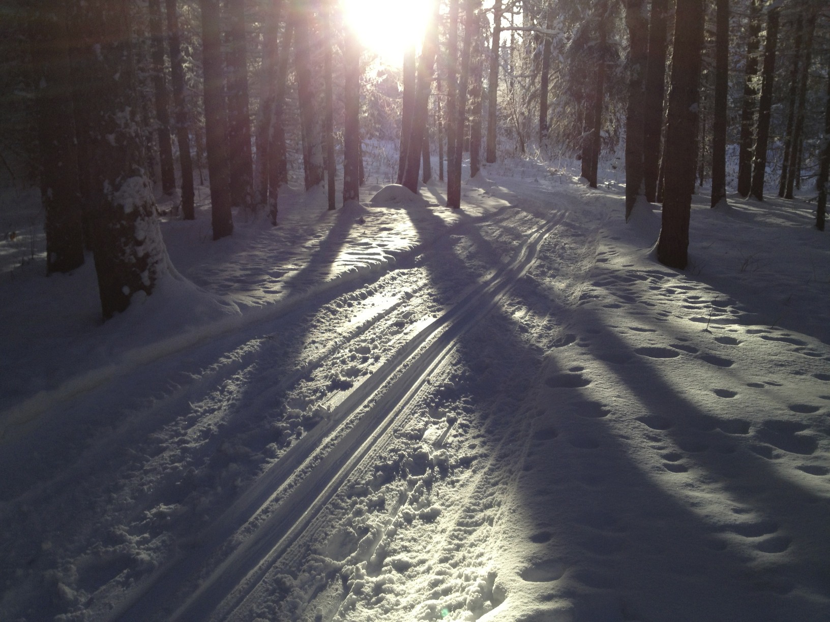
Recreation is one of the key uses of Cranbrook Hill. Horseback riding is common seeing as many of the residents on Cranbrook Hill and surrounding areas own horses. Cyclists and hikers use Cranbrook Hill, especially on the well established trail system at Forests for the World (FFTW) and the Otway Ski Center. In addition to these established trails, old trails and logging roads, many of which join to the greenway, lend themselves to these activities. One of the main winter uses is X-country skiing, in which groomed trails exist at the Otway Ski Center at the northern terminus of the Cranbrook Hill Greenway. In 1982 the Hickory Wing Ski Club acquired a lease from the City of Prince George to develop ski trails at a site off of Otway Road, now referred to as Otway Ski Center. In 1984, the Hickory Wing Ski Club disbanded into two clubs, presently known as the Caledonia Nordic Ski Club (CNSC) and the Alpine Ski Club of Prince George. Today the CNSC has a membership of 1000 and provides 3.6 kilometers of lighted track and 40 kilometers of track that can be skied in the day time. FFTW contains X-country ski trails that are more suitable for recreational skiers over racers. Snowmobiling is also a common use on Cranbrook Hill, however people are reminded that the greenway is not accessible to motorized use.
In addition, Cranbrook Hill is home to the University of Northern British Columbia. UNBC is a state-of- the-art education facility that began development in 1993. UNBC is a relatively small university, with the capacity to accommodate 2800 students, while offering unique programs and atmosphere for the attending population. The Cranbrook Hill Greenway will offer a great nature escape for UNBC students in all seasons.
Section 4: Route Description
Overall Route Description
Take a tour on the greenway trail and enjoy the varied landscape and natural beauty of Cranbrook Hill. At UNBC, one can connect to Forests for the World (FFTW), continue south to the Blue Spruce Campground on Kimball road, or travel north-west to the Otway Ski Center.
UNBC to FFTW (0.8 km)
Travel on a trail surrounded by a mixed-wood forest with large birch trees to the greenway trail head sign at the south-east corner of FFTW.
UNBC to Blue Spruce (6 km)
An open canopied forest with large birch trees and lush understory is encountered initially. At the UNBC/Blue Spruce/Otway junction, one must travel south to reach Blue Spruce. The forest is dense and is comprised of large Interior Douglas-fir trees with evidence of past logging activity. A climbing rock can be accessed to the east of the greenway trail at the 2.75 km and 3.20 km marks. A viewpoint of hills to the south-east is reached at the 3.8 km mark, at which point Kimball road is followed to Blue Spruce.
UNBC to the Otway Ski Center (18 km)
At the UNBC/Blue Spruce/Otway junction, one can travel north-west to Otway. After a mild ascent, the trail reaches a high point with panoramic views of mountains. The trail then descends to a beaver marsh and small lake, and eventually passes old mine diggings nestled in a rock outcrop. The old Sawdust Pile road is eventually crossed, and the headwaters of the major drainage of the greenway is reached, at which point the trail follows the drainage for 4 km. The trail alternates between open, south facing slopes with colorful meadows, and forested north facing slopes. As one leaves the drainage, the trail enters a private woodlot with a dense, predominately pine forest. The trail eventually crosses Takla Road and continues on to a brook crossing which indicates the northern border of a woodlot where one emerges from forest and parallels a regenerating forest on private property. Once again, the greenway enters a denser forested area of Interior Douglas-fir and spruce, with birch groves. With a slight fall in altitude, the greenway enters the Otway ski trails. The trail descends beside a small creek until it reaches the biathlon area. The final 1.5 km of the trail meanders through a lodgepole pine forest until it reaches the parking area at the Otway Ski Center.
Section 5: Safety & Etiquette
The main purpose of the greenway is to provide a safe natural experience to urban users. Certain issues must be examined to provide a reasonable level of safety on the greenway. The society will be responsible for some safety issues of the greenway, but the etiquette of trail users will also have a strong impact on the safety of the area.
Wilderness areas are inherently hazardous for several reasons, one being that medical aid is not as available as it is in urban and suburban regions. Hence, users should be aware of their isolation and plan accordingly while recreating in the greenway. Users are encouraged to carry enough food and drink, seeing as these are limited on the greenway. Another safety issue is to remain orientated at all times, so as to allow relatively easy exit from greenway to reach medical aid if needed. To this end, trail markers have been installed frequently enough along the greenway so that if one is standing at or just past a marker the next marker is visible. The society will make any effort to inform users of their nearest access point by providing brochures at each major access outlining distances between the access points. This should give users the ability to determine the access point that will provide the quickest way to reach medical aid if needed.
Beyond making the users aware of their isolation, the society has an added obligation to make the greenway as safe as it reasonably can. Debris, roots, rocks, stumps, and dangerous snags have been removed from the trail tread surface and canopy to lessen the chance of user’s injuring themselves while on the greenway. In addition, bridges and boardwalks will be regularly maintained for the safety of all users.
The design of the trail was developed with safety issues in mind. The width of the trail was designed to allow the comfortable passage of multi-user groups bidirectionally, therefore minimizing the chance of collisions between users. To further lessen the chance of user collision, cyclists and horseback riders are requested to yield to pedestrian traffic and use the greenway with caution. No motorized vehicles are allowed on the trail, for both safety and environmental reasons. In addition, no shooting is permitted within the greenway boundaries. Most importantly, users are reminded to respect private property, seeing as the greenway was made possible through the cooperation of private property owners.
User interaction with wildlife, especially with larger species such as moose and bear, is also a safety concern. All wild animals on the greenway are potentially dangerous and may be encountered at any time. Several strategies can help to prevent unwanted conflict between users and wildlife. The worst circumstance would be to surprise a bear! Making sufficient noise while on the greenway is an effective method to deter wildlife. Using a bell or whistle, and talking intermittently should be enough noise to alert wildlife of your presence. If bear signs are found, such as skat, tracks or diggings, make extra noise to warn them of your presence. If approached by a bear, stay calm and don’t run, but move slowly away if possible. Also, carry bear spray for added protection and avoid carrying food with strong aromas such as tuna or salmon sandwiches. To attain further information on bear safety, contact the local parks branch for pamphlets. Warning signs and information on wildlife safety will also be posted on trail head signs at major access points.
Section 6: Conservation
The Cranbrook Hill Greenway Society has achieved their initial goal of establishing greenway boundaries and acquiring public and private land to connect the south and north ends of Cranbrook Hill. The Cranbrook Hill Greenway is a linear area that will be protected from other developments on Cranbrook Hill, such a logging, agricultural leases and residential construction. The greenway will provide an area buffered from the hustle of urban life in the face of future development on Cranbrook Hill.
Now that the greenway is established, maintaining a healthy ecosystem of the greenway is one of the management goals that the Cranbrook Hill Greenway Society strives to achieve. Proper maintenance of the greenway trail and protection of sensitive areas like marshes is important in preserving the ecosystem. The society is not solely responsible for the conservation of the greenway, for the etiquette of trail users will have a strong impact on the survival of this protected area.
Many factors could contribute to the deterioration of the greenway’s natural beauty. Activities such as refraining from picking wildflowers and packing garbage out of the area will help sustain a pleasant environment. It must not be forgotten that wildlife are the primary users of the greenway, hence should be respected if encountered on the trail. Wildlife species of the greenway most susceptible to disturbance are moose and black bear. Sightings and animal dropping of these species predominately occur in riparian areas, especially along the long drainage in the middle of the greenway. Even though non-motorized use should cause minimal disturbance to these two key species, frequent surprises could cause these species to avoid the area. In most cases, the route has been flagged far enough from favored riparian habitat of moose and bear, therefore conflict between humans and these species should be minimal. Cement dividers are placed at some access points to prevent motorized vehicles from using the greenway. If motorized vehicles are sighted on the greenway, users are asked to report all such cases to the Cranbrook Hill Greenway Society. Please phone 962-2923 with a description, license plate, make, model, color, etc. of the vehicle if possible.
Maintaining native vegetation is also important to sustain viable communities on the greenway. Native vegetation provides food for wildlife communities, and contributes to the uniqueness that nature is so often admired for. Non-native seeds could be carried onto the greenway by horses via their feces and fur, therefore owners are asked to carry a collection device for their horse’s feces while on the greenway. Non-native seeds have been known to aggressively over take natural vegetation, hence it is important to minimize their presence on the greenway. In addition, grazing and trampling by horses and humans could destroy plant life and soil structure that are imperative to limiting erosion on the greenway. To help preserve the greenway, users are asked to stay on marked trails, especially in sensitive areas such as wetlands and drainage systems. Riparian environments are valuable for wildlife habitat in that they have woody plant communities with structural variation, surface water and soil moisture and spatial heterogeneity of habitat.
By practicing the conservation strategies discussed above, the Cranbrook Hill Greenway should be capable of sustaining biodiverse wildlife communities, as well as naturalist and recreational activities for future generations.
Section 7: Greenway Society
History of the Society
The idea of establishing trails on Cranbrook Hill began in the 1970’s between various groups and the local government of Prince George. Individuals such as Bjorn Norheim (Sons of Norway), Yvonne Harris (Director of Regional Planning), and others corresponded about the idea of creating “recreational corridors” on the west side of Cranbrook Hill. Bjorn Norhiem surveyed potential sites in the areas of Miworth, Otway road, and Takla road. Some trails were developed, especially in the area of Otway road where the Otway Ski Center presently resides. However, due to the lack of funding in the 1980’s the project was discontinued.
A renewed interest began in the 1990’s when Robin Draper (BC Parks Recreation Officer) introduced the “Greenway Concept” and offered his expertise in starting a project of such magnitude. A 1991/92 survey was conducted at the Otway Ski Club and 84 % were in favor of a recreational area linking the Center to UNBC and Parkridge creek. Due to this significant amount of interest, the Cranbrook Hill Trail Task Group was organized in November 1994 by a group of Prince George residents who were interested in establishing a greenway connecting the Otway Ski Center, UNBC, Forests For The World and Parkridge Creek. The vision statement of the Cranbrook Hill Trail Task Group in June 1995 was:
Working towards the preservation of a right of way, and identifying a series of adjacent recreation areas, for a greenway linking Parkridge creek at Highway 16 to UNBC to Forests for the World to the Otway Ski Center. This process will also include identifying and preserving key access points. The right of way will form the backbone of future trail and recreation development on Cranbrook Hill.
This statement appeared in the Cranbrook Hill Greenway Proposal which was presented to BC Lands, the City of Prince George and the Fraser Fort George Regional District, after which the Cranbrook Hill Trail Group was disbanded and the Cranbrook Hill Greenway Society was formed in October 1995.
Legal Status of the Society
The Cranbrook Hill Greenway Society has contacted and dealt with various agencies in order to make the greenway official. On September 14, 1995 the City of Prince George applied for a License to Occupy all lands covered by the proposed greenway from the Crown. This included lands inside and outside the municipal boundaries. The Crown referred the application to all other agencies required and began to compile the parcel identifiers for the License. On March 4, 1996 the City agreed to purchase certain lands, negotiate a right-of-way and sign a lease with the Crown. In April 1996 the City informed the Cranbrook Hill Greenway Society that the Council had approved a recommendation to enter into a License of Occupation with BC Lands for the Cranbrook Hill Greenway. In addition, the Agriculture Land Commission approved the greenway in the Agriculture Land Reserve sections.
One of the key steps towards securing long term tenure for the Greenway was the completion of the agreement between BC Lands and the City of Prince George. The final details of the agreement were completed at the end of year 1996 and the formal signing took place early in 1997. Now that this process is complete, the city of Prince George is in agreement with the Cranbrook Hill Greenway Society to develop and manage the greenway.
Purpose and Structure of the Society
The Cranbrook Hill Greenway Society is a non-profit organization that is a cooperative venture between organized trail user groups, public agencies and individuals that have an interest in the Cranbrook Hill Greenway. One of the purposes of the society is to develop, manage and maintain the greenway and associated trails on Cranbrook Hill. The society encourages safe and wise use of the Cranbrook Hill Greenway and associated trails by encouraging programs of safety and outdoor ethics. Furthermore, the society works together to acquire funds and expertise to ensure all the objectives of the society are met.
The society has an official board of directors and members classified into three groups; organizations, advisory, and public agencies. Organizations include groups involved with the outdoors and activities including hiking, running, cycling, X-country skiing, and horse-back riding. Organized trail user groups with an interest in the objectives of the Society may apply for membership and on acceptance by the Directors shall be a member of the Society and have one vote exercised through a delegate to the Society. This delegate shall be named by the Organized Group and a letter of accreditation sent to the Society.
Advisory members are individuals that do not represent an organization, but who have specific expertise and/or interest in the objectives of the Society and whose participation would broaden the capability of the Society. These individuals may be invited by the Directors to be a member and participate in the work of the Society. Advisory members are not eligible to vote except when elected to the Board of Directors.
Lastly, public agencies with an interest in the objectives of the Society may apply for membership and on acceptance by the Directors shall be a member of the Society and have one vote exercised through a delegate to the Society. This delegate shall be named by the Public Agency and a letter of accreditation sent to the Society.
The 1997 list of organizations and public agencies is as follows:
- Caledonia Nordic Ski Club
- Caledonia Ramblers
- Dusty Trail Riders
- Northern BC Arabian Breeders Association
- Prince George Cycling club
- Prince George Horse Society
- Prince George Naturalists Club
- Prince George Road Runners
- Prince George Triathlon Association
- Sons of Norway
- UNBC Outdoor Club
- University of Northern British Columbia
- Forests for the World
- City of Prince George Parks Development
The private sector also sponsors the Cranbrook Hill Greenway Society. Early in the developmental stages of the Cranbrook Hill Greenway Society project, Canfor voiced a desire to become involved and committed $25 000 to be spent over 5 years to the project.
Overall, the Cranbrook Hill Greenway Society has diverse membership and welcomes new members in hopes to attain more expertise and a greater volunteer base (Contact Robin Draper at 250-962-2923).